Many businesses create an Emergency Action Plan (EAP) or a similar document to detail the steps of action and chain of command during an emergency. These types of plans also document the monitoring and management of physical rapid response tools and equipment.
Emergency asset location refers to the physical location of emergency equipment like fire extinguishers, AED equipment, and security devices. These assets are available to support safety actions during an emergency; accurate location information is critical to life-saving measures.
To support their EAP, many businesses, schools and hospitals rely on safety maps that include emergency asset location.
What Kind of Emergency Assets Should be Mapped?
Safety maps can take different forms. Most businesses post fire evacuation maps and severe weather maps in prominent, visible locations so that employees and visitors can both find the nearest egress route with ease. Another type of safety map is a security map. Typically, these are kept in an administrative office and distributed to law enforcement and other qualified personnel during a security incident.
Emergency asset maps may include any of the following emergency features and safety assets:
- Fire extinguishers
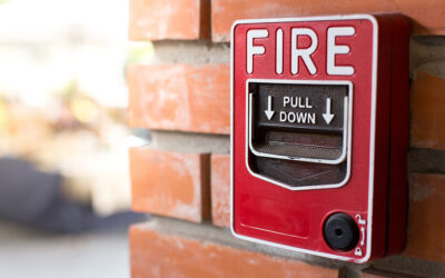
- Fire pulls
- Fire panel
- Fire hydrants
- First aid kits
- AED equipment
- Water, gas, and electric shutoffs
- Knox box and SDS sheets
- Alarm control panels
- ID card access points
- Security cameras
- Security guard booths
While utility shutoffs are unlikely to move, building layouts can change frequently and smaller items like fire extinguishers and first aid kits may be relocated. Keeping up-to-date maps of these security assets is crucial, because in an emergency, taking an extra minute to hunt down a life-saving device can make a huge difference.
Digital Mapping Services Can Help You Accurately Locate Your Emergency Assets
If you’re renting your space, finishing up renovations, or finalizing a new layout, you may not have access to up-to-date floorplans with current emergency asset information. While it is certainly possible to create a list of your emergency assets, pull out your measuring tape, and write down the distances for emergency mapping, technology has made this process much easier.
3D laser scanning, photogammetry, and drones can now provide precise measurements for building layouts, safety assets, and even 3D digital building recreation. These building scanning tools can be used on multi-story buildings like hospitals and apartment buildings, complex layouts like manufacturing businesses, and extensive campuses like schools.
All you have to do is give Building Maps a call and our team will walk through your building with our state-of-the-art tools, to provide you with an accurate and complete building layout. We will also survey and identify the necessary emergency assets, then ensure they are correctly located on your final safety maps.
Call Building Maps for Mapping Accurate Emergency Asset Locations
In an emergency, up-to-date floorplans and emergency asset locations can make a critical difference. Accurate access to life-saving devices can prevent a tragedy, and can also shield you from loss of equipment and risk of litigation.
At Building Maps, we take safety mapping seriously, because we know that lives are at stake. Our team can handle every step of the process for you, from digital building scanning to high-quality, intuitive illustrations of building layouts and egress routes.
To learn more about our services, please contact us today. We’ll help you update your critical safety and security information with professional maps that include emergency asset location.